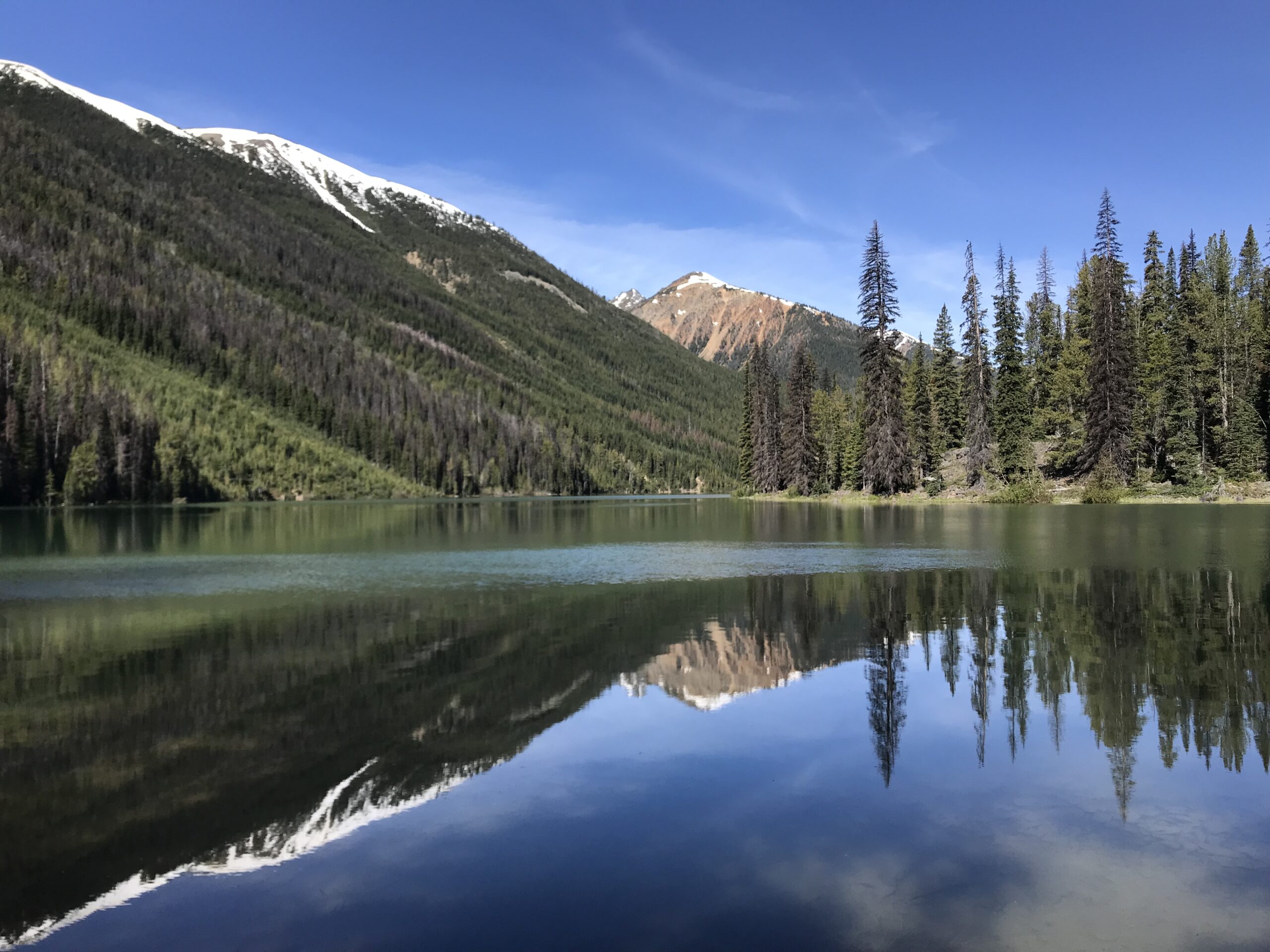

The South Chilcotin Mountains Provincial Park is a relatively unknown destination not too far away from Vancouver. It’s a new park, established only in 2010, and a wilderness area ie., it’s sparse on facilities and has no regular ranger patrols. Horse-packers have been going there for more than 100 years, and of late, it’s also become popular among mountain bikers, so the trails there are well-established – for the most part (more on this in the trip report). That, combined with the fact that it’s drier in that part of BC, and thus less snow this time of the year, makes it a good choice for an early season backpacking trip in the mountains.
The plan was to spend 7 whole days there, which was going to be the longest stretch I’ve done in the wild. We hiked a nearly 100 kms long clockwise loop around the park, saw bears (from safe distances!) and gorgeous alpine landscapes, swam in cold lakes, crossed many, many creeks, and overall had a wonderful time away from people.
Some other trip reports for reference: this one from August 2014 and this one from August 2020.
And our meal plan: as we had to carry food for a week, we wanted to be careful about bringing enough food, even a bit extra, but not so much that it’s a pain to lug things around. We calculated about 500 calories per person for the dinners, split into protein and carbs so we knew exactly how much of what to bring for each meal.
- Breakfasts: Mostly oatmeal with spice mixes (savoury for me, sweet for Felix) and instant coffee
- Lunches: Bagels with (vegan) cheese for me, pumpernickel and crisp bread with nut butters and cheese for Felix
- Dinners: We had quite the variety, details are in each day’s description, but in short we used couscous, rice, mashed potatoes, pasta and noodles as our carb bases.
- Snacks/Misc: trail mix, chocolate, nuts, gummy bears, soup mixes, Clif bars

Getting There
There are two ways to get there, either via Lillooet, or via the infamous Hurley Forest Service Road. Both have sections that are pretty rough and unpaved. The Hurley route is much shorter, but is gravel all the way and is often washed out. Your best bet would be to stop by at Pemberton and ask around to see if anyone has driven on it recently and can vouch for the conditions. Google maps doesn’t have the entire Hurley on it, and only navigates through the other route. We drove in via Lillooet, following Google’s directions, but after hearing about the Hurley from a few folks, took that route on the drive back and it was much shorter.
Trip Report
Day 0, Friday
Distance hiked: 0 kms
Camped at: Gun Creek campground
We started from Vancouver in the evening, so we spent most of the time on the road. We stopped by at a farm in Pemberton for farm-fresh strawberries, and grabbed some beers and filled up a growler from the Pemberton Brewing Company. Along the way, we noticed how the scenery was changing: coastal rainforests giving way to dry soil and desert-like shrubs.
We spent the night at one of BC Hydro’s many, free-to-use campgrounds in that area – Gun Creek campground. We didn’t know it yet, but we would be seeing a lot more of this creek. Much of our first day’s hike would be following it upstream.
Dinner was potatoes with an onion-tomato sauce, made by Felix. It was the last time we’d be eating anything fresh for a whole week!
Day 1, Saturday
Distance hiked: 18 kms
Elevation gained: ~500 m
Camped at: Hummingbird Lake
We started out very early, before we’d even eaten breakfast, but only because Euro 2020 was going on, and Germany was playing Portugal that day. That’s how we found ourselves at the only motel/bar/restaurant in Gold Bridge, at 8.30 am, watching the match over coffee, that soon turned into beers. Because it’s tradition.
Finally at 1 pm, after brunch at the Jewel Bridge trailhead, we set off.
There was a bit of rain on the way, and we saw 3-5 deers and 2 black bears. The bears were about 100 m away from the trail and did surprise us a little. After that, a little bearanoia set in, and we sang and whistled and talked loudly till we reached Hummingbird Lake. We were pleasantly surprised to find that we had this gorgeous lakeside campsite all to ourselves. There were fire pits near each tent site, an outhouse, a picnic table, bear caches, a large communal fire pit with makeshift benches and even … an axe to cut firewood!


That was also the day we ran into the most number of people during the trip. Most were mountain bikers, heading out from the Spruce Lake area.
Dinner was peanut noodles, followed by some soup made using the noodle water, dried vegetables and some soup mix powder.
Day 2, Sunday
Distance hiked: 11 kms
Elevation gained: ~830 m
Camped at: Deer Pass
Had a lazy start that morning, sleeping in (had one of the best sleeps ever!), washing up, and drying things that needed drying from yesterday’s rain. When we finally packed up and got going, it was 1 pm again. We hiked past Trigger Lake, another beautiful lake-side campsite, to reach our destination for the day 6 hours later.


Most of the going was more or less flat, until the junction with Warner Lake Trail, at which point it suddenly changed to steep switchbacks. Along the way we saw many mushrooms, some that looked very, very edible but not knowing for sure, we let them be. We took a lunch break around 1900 m, as there was still some elevation to be gained and we needed fuelling up. Lunch was a cold “pizza” for us: a bagel or pumpernickel bread with tomato paste and slices of vegan cheese, sprinkled with some pepper flakes and olive oil.


We hit snow around 2000 m, but the snow line depended hugely on whether the slope was north-facing, or south-facing, and on our route it was pretty patchy. While Deer Pass is marked as a campsite on some maps, it’s really just a little basin where you can fit a tent or two. We had strayed off the main trail, so we camped a little higher, at 2350 m. The view was spectacular, especially over sunset.


The rest of the trip continues in part 2!
Pingback: Backpacking in the South Chilcotin Mountains Part 2 - Beyond Trail Mix
Great content.. love to see you share all bits and parts of it. I am a vegetarian dietitian traveller too and it’s so important to keep nutrition profile of food dense and packed while hiking.. keep it up
Thanks! If you try any of the recipes here, I’d love to hear your take/feedback on it 🙂
Pingback: Backcountry Basics: 3-Ingredient Pizza Bagel - Beyond Trail Mix
Thanks for your blog, nice to read. Do not stop.
Pingback: Backpacking the Sawback Trail Part 3 - Beyond Trail Mix